GEUS metadata
Deep Geothermal Energy Portal
Dyb geotermi-portal
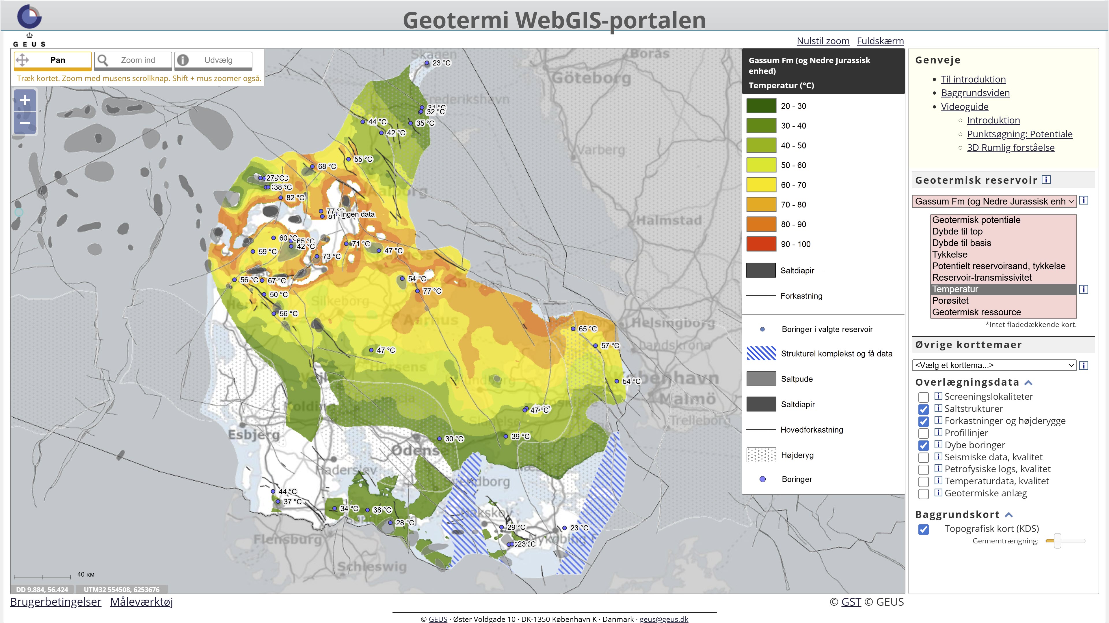
The Deep Geothermal Portal is a web-based map portal providing access to geological data and maps related to deep geothermal energy resources in Denmark. The portal includes a range of 3D depth maps of geothermal reservoirs as well as thematic maps showing key geological parameters and factors relevant to geothermal production potential.
The maps provide information on parameters such as depth to geological formations, reservoir thickness, temperature and porosity in geological units that may be relevant for deep geothermal utilisation. The portal also includes a geological screening of the subsurface beneath 28 mainly urban areas selected in cooperation with the Danish Energy Agency in order to assess the potential for geothermal energy.
The first map presented in the portal is the geothermal potential map. This map indicates where geological layers within the depth interval of approximately 800–3000 metres contain sandstone units with favourable reservoir properties. The map provides a regional overview of areas that may be most promising for deep geothermal utilisation and may help reduce the risk of investments in geothermal projects.
The portal therefore provides an overview of GEUS’ mapping and assessment of geothermal resources in the Danish subsurface and serves as an entry point to further information about the underlying geological data and interpretations.
Dyb geotermi-portalen er en webbaseret kortportal, der giver adgang til geologiske data og kort relateret til dyb geotermisk energi i Danmark. Portalen indeholder en række 3D-dybdekort over geotermiske reservoirer samt tematiske kort, der viser centrale geologiske parametre og forhold af betydning for de geotermiske produktionsegenskaber.
Kortene giver blandt andet information om dybde til geologiske formationer, reservoirtykkelse, temperatur og porøsitet i de geologiske lag, der kan være relevante for udnyttelse af dyb geotermi. Portalen indeholder desuden en geologisk screening af undergrunden under 28 primært bynære områder, udvalgt i samarbejde med Energistyrelsen, med henblik på at vurdere potentialet for geotermisk energi.
Det første kort i portalen viser et overordnet geotermisk potentiale, som indikerer hvor i undergrunden der forekommer lagpakker i dybdezonen 800–3000 meter med sandstenslag, der forventes at have gode reservoiregenskaber. Kortet er udarbejdet for at give et regionalt overblik over de mest lovende områder for dyb geotermisk udnyttelse og kan bidrage til at reducere risikoen ved investeringer i geotermiske projekter.
Portalen giver dermed et samlet overblik over GEUS’ kortlægning og vurdering af det geotermiske potentiale i Danmarks undergrund og fungerer som indgang til yderligere information om de geologiske data og tolkninger.
Simple
-
Date (Publication)Date (Publication)
- 2016-08-07
- Point of contact
-
Organisation name Individual name Electronic mail address Role Geological Survey of Denmark and Greenland (GEUS)
De Nationale Geologiske Undersøgelser for Danmark og Grønland (GEUS)
Henrik Vosgerau
Henrik Vosgerau
Point of contactPoint of contactGeological Survey of Denmark and Greenland (GEUS)
De Nationale Geologiske Undersøgelser for Danmark og Grønland (GEUS)
Anders Mathiesen
Anders Mathiesen
Point of contactPoint of contact
-
ThemeTheme
-
-
Web portal
Webportal
-
Energy
Energi
-
Subsurface
Undergrund
-
Reservoir
Reservoir
-
Geothermal
Geotermi
-
EGDI
EGDI
-
-
Access constraintsAccess constraints
-
Other restrictionsOther restrictions
-
Use constraintsUse constraints
-
Other restrictionsOther restrictions
-
Other constraintsOther constraints
-
The Deep Geothermal Portal provides access to geological maps and thematic geoscientific data produced by GEUS related to deep geothermal energy in Denmark. The maps and data displayed in the portal represent visualisations of geological mapping and interpretations by GEUS based on available data and may be updated as new knowledge, improved datasets or revised geological interpretations become available.
The maps and information in the portal are intended for general information and geoscientific purposes. They do not constitute detailed local geological or geotechnical assessments and cannot be used directly as a basis for engineering design, drilling or development of geothermal installations without further investigations.
If more detailed geological information or higher-resolution data are required for specific purposes, users are encouraged to contact GEUS for further information about the available data, their appropriate use and possible supplementary investigations.
Dyb geotermi-portalen giver adgang til geologiske kort og temadata udarbejdet af GEUS vedrørende dyb geotermisk energi i Danmark. Kort og data vises i portalen som visualiseringer af GEUS’ geologiske kortlægning og tolkninger baseret på tilgængelige data og kan løbende blive opdateret i takt med ny viden, forbedrede datagrundlag eller reviderede geologiske tolkninger.
Kort og information i portalen er udarbejdet til generelle informations- og geovidenskabelige formål. De udgør ikke en detaljeret lokal geologisk eller geoteknisk vurdering og kan ikke anvendes som direkte grundlag for projektering, boring eller etablering af geotermiske anlæg uden yderligere undersøgelser.
Hvis der er behov for mere detaljerede geologiske oplysninger eller data med højere detaljeringsgrad til specifikke formål, anbefales det at kontakte GEUS for nærmere information om datagrundlag, anvendelsesmuligheder og eventuelle supplerende undersøgelser.
-
Other constraintsOther constraints
-
CC BY 4.0CC BY 4.0
-
Service TypeService Type
- Application
-
DescriptionDescription
-
Denmark
Danmark
))
-
Coupling TypeCoupling Type
-
LooseLoose
- Contains Operations
-
Operation Name Distributed Computing Platforms Connect Point Web portal
Web servicesWeb serviceshttps://data.geus.dk/geusmap/?mapname=subsurface_grl
-
Reference system identifierReference system identifier
-
ETRS89 / UTM 32N (EPSG:25832)ETRS89 / UTM 32N (EPSG:25832)
- Distribution format
-
Name Version HTML
- Distributor contact
-
Organisation name Individual name Electronic mail address Role Geological Survey of Denmark and Greenland (GEUS)
De Nationale Geologiske Undersøgelser for Danmark og Grønland (GEUS)
GIS-Support
GIS-Support
DistributorDistributor
Digital transfer options
Digital transfer options
- OnLine resource
-
Protocol Linkage Name WWW:LINK-1.0-http--link
https://dybgeotermi.geus.dk/ Deep Geothermal
Dyb geotermi
WWW:LINK-1.0-http--link
https://data.geus.dk/geoterm/ Deep geothermal WebGIS Portal
Dyb geotermi WebGIS-Portalen
-
Hierarchy levelHierarchy level
-
ServiceService
- Other
-
Service: Web portal (Application)
Metadata
-
File identifierFile identifier
- 1179cad6-dd79-42b8-a1b1-d38495f21665 XML
-
Metadata languageMetadata language
- English
-
Character setCharacter set
-
UTF8UTF8
-
Hierarchy levelHierarchy level
-
ServiceService
- Hierarchy level name
-
Web portal (application)
-
Date stampDate stamp
- 2026-09-28T11:16:22.030445Z
- Metadata standard name
-
ISO 19115:2003/19139
- Metadata standard version
-
1.0
- Metadata author
-
Organisation name Individual name Electronic mail address Role Geological Survey of Denmark and Greenland (GEUS)
De Nationale Geologiske Undersøgelser for Danmark og Grønland (GEUS)
Point of contactPoint of contact
- Other language
-
Language Character encoding DanskDanishUTF8UTF8EngelskEnglishUTF8UTF8