 GEUS metadata
Hardness of Danish drinking water
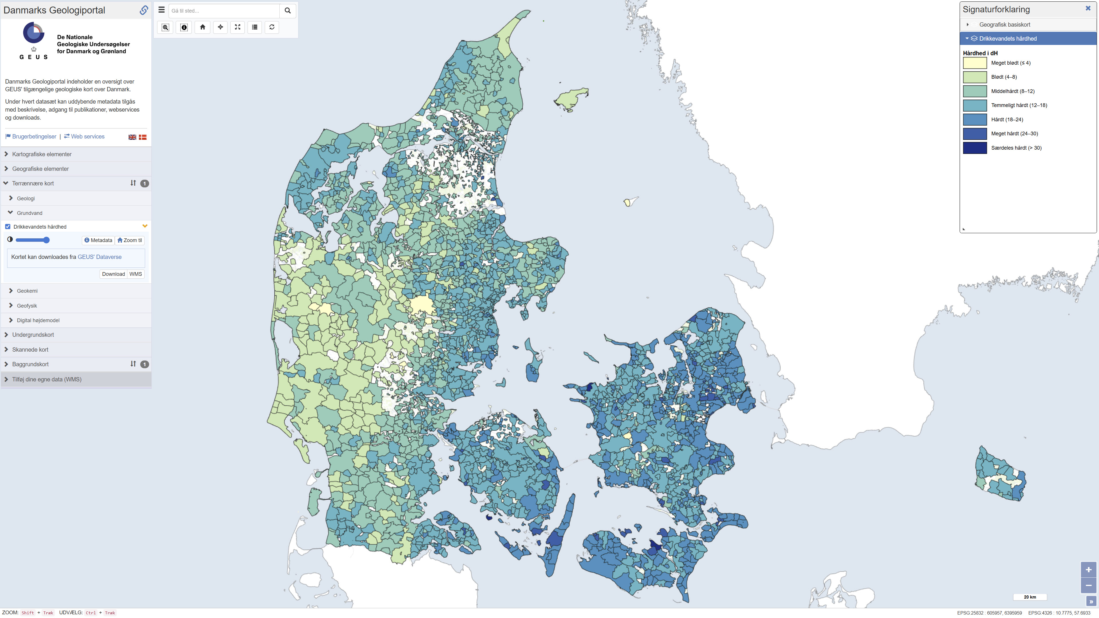
Map showing information about drinking water hardness (dH) at the level of water supply areas of public waterworks in Denmark based on quality-assured data, extracted from the national well-database Jupiter in September 2023. The hardness degree is based on the concentration of calcium and magnesium in the drinking water and has importance, for example, for the soap dosage when washing clothes: hard water requires more soap than soft water. Drinking water hardness may vary considerably from location to location and in time. Contact your water utility company to get the updated and precise figures.
Simple
- Date (Publication)
- 2024-09-05
- Citation identifier
- dk.geus / drikkevands_haardhed
- Presentation form
- Digital map
- Purpose
-
The purpose of this map is to show the variation of drinking water (DW) hardness in Denmark based on the data available in 2023. DW hardness is an important technical characteristic of tap water in relation to precipitation of carbonates in water pipes, boilers and other hot water household appliances, as well as in relation to increased soap use. The data have also potential relevance to different authorities and industries.
- Status
- Completed
- Point of contact
-
Organisation name Individual name Electronic mail address Role Geological Survey of Denmark and Greenland (GEUS)
GIS-support
Point of contact Geological Survey of Denmark and Greenland (GEUS)
Birgitte Hansen
Custodian
- Maintenance and update frequency
- As needed
- Metadata author
-
Organisation name Individual name Electronic mail address Role Geological Survey of Denmark and Greenland (GEUS)
GIS-support
Point of contact
- Theme
-
-
Dataset
-
Geology
-
Drinking water
-
ArcGIS
-
- Access constraints
- Other restrictions
- Use constraints
- Other restrictions
- Other constraints
- CC BY 4.0
- Spatial representation type
- Vector
- Denominator
- 100000
- Language
- Dansk
- Character set
- UTF8
- Topic category
-
- Geoscientific information
- Environment
))
- Supplemental Information
-
None specified
- Reference system identifier
- ETRS 89 / UTM 32N (EPSG:25832)
- Distribution format
-
Name Version WMS
REST
WMTS
- Distributor contact
-
Organisation name Individual name Electronic mail address Role Geological Survey of Denmark and Greenland (GEUS)
GIS-support
Distributor
Digital transfer options
- OnLine resource
-
Protocol Linkage Name DOI
https://doi.org/10.22008/FK2/5OZV7W Download
WWW:LINK-1.0-http--link
https://data.geus.dk/geusmap/index.jsp?mapname=denmark&lang=da#baslay=&optlay=&extent=152468.15631191875,5968370.043160659,981533.2402930192,6463665.6196479825&layers=drikkevandets_haardhed,openstreetmap_basemap_dk Interactive webmap
OGC:WMS-1.3.0-http-get-capabilities
https://data.geus.dk/arcgis/services/Denmark/Drikkevandets_haardhed/MapServer/WMSServer?request=GetCapabilities&service=WMS Drikkevandets_haardhed
ESRI:REST
https://data.geus.dk/arcgis/rest/services/Denmark/Drikkevandets_haardhed/MapServer Drikkevandets_haardhed
OGC:WMTS-1.0.0-http-get-capabilities
https://data.geus.dk/arcgis/rest/services/Denmark/Drikkevandets_haardhed/MapServer/WMTS/1.0.0/WMTSCapabilities.xml Denmark_Drikkevandets_haardhed
- Hierarchy level
- Dataset
- Statement
-
The map is based on the latest available hardness information at the water supply areas of public waterworks. The public waterworks metadata and drinking water analyses of Ca, Mg and total hardness were extracted from the Jupiter database on 6 September 2023. The water supply areas are from Schullehner (2022, https://doi.org/10.34194/geusb.v49.8319). Data were quality assured, filtered, aggregated and linked together.
Metadata
- File identifier
- 27f53f24-c0b6-4c6a-8e1d-b53071461f74 XML
- Metadata language
- Dansk
- Character set
- UTF8
- Hierarchy level
- Dataset
- Date stamp
- 2026-08-23T09:26:07.43951Z
- Metadata standard name
-
ISO 19115:2003/19139
- Metadata standard version
-
1.0
- Metadata author
-
Organisation name Individual name Electronic mail address Role The Geological Survey of Denmark and Greenland (GEUS)
GIS-support
Point of contact
- Other language
-
Language Character encoding English UTF8 Danish UTF8
)))